 Fire & EMS Leader Pro The job of old firefighters is to teach young firefighters how to become old firefighters!
Sponsored Content: 100 Feet–Geospatial Mapping for the 21st Century
By: Robert Avsec, Executive Fire Officer
The following is a plausible scenario based on my own anecdotal experience as a manager for a county PSAP.
The Fresno (Calif.) PSAP (Public Safety Answering Point) receives the following 911 call for assistance.

911 Call Taker: “911, What’s your emergency?”
Caller: “I think I’m having a heart attack!”
911 Call Taker: “OK Sir. I’m going to get you help. Can you tell me your address?” (The 911 call is coming from a wireless phone and the system is having difficulty locating the phone).
Caller: “I don’t know. God, my chest hurts so bad! Please help me!”
911 Call Taker: “Sir, I’m going to get you help. Can you tell me where you are in Fresno?”
Caller: “No. I was just here to meet an old friend, but I don’t live here. Please hurry!”
911 Call Taker: “Sir, are you outside or in a car?”
Caller: “I’m in my car.”
911 Call Taker: “What make and color car?”
Caller: “A white Honda Accord. My car is a white Honda Accord. Please hurry. My chest hurts so bad!”
911 Call Taker: “Sir, I understand, and I’m gonna help you. I need you to look around you and tell me what buildings you can see?”
Caller: “I see a Subway restaurant.”
911 Call Taker: “That’s good. What else can you see?”
Caller: “I see some big old official looking buildings.”
911 Call Taker: “Like government buildings?”
Caller: “Yes! That’s it! Like court buildings! OH, now my arm and jaw are hurting terribly! Please hurry!”
At this point, the public safety telecommunicator (PST) pulls up those two building and occupancy types in CADS. The information on her screen (Figure 1 below), which also shows satellite imagery of the area with all the buildings labeled, indicating that the caller is somewhere on Fulton Street in the vicinity of the Subway and the Fresno County Department of Health and the Fresno Public Health Lab. She sends the call to the PST working on EMS radio for them to dispatch the appropriate ambulance to the general location.
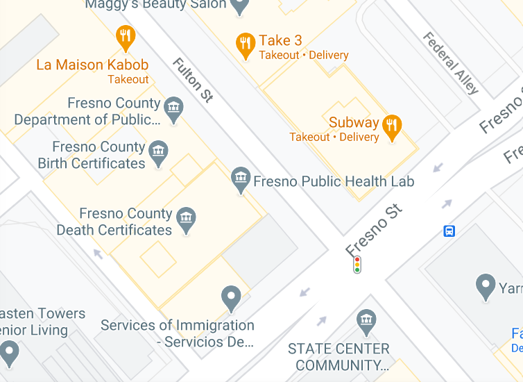
911 Call Taker: “Sir, can you see Take 3 or La Maison Kabob? They’re two restaurants near you.”
Caller: “Yes, yes I can! please hurry.”
911 Call Taker: “Sir, I already have an ambulance headed to you. Now listen carefully as I’m going to assist you until they arrive and tell me they have you, OK?”
Caller: “OK, yes. Yes, thank you!”
Has that scenario or one like it ever happened to one of your PSTs? (aka, dispatchers, 911 operator, 911 call taker). Sure, it has. Just as it has for any PSAP. And when it did, a successful outcome, locating the patient and directing EMS to that location, was likely very dependent upon the knowledge of the buildings, landmarks, and geography, of the PST handling the call, right? Quite a “roll of the dice,” no?
Well, it doesn’t have to be a game of chance anymore. Because like the PST in this scenario, the technology is now available to put that kind of information on the computer screen of every PST in your locality’s PSAP.
And even better, the PST can send that same level of information to the responding resources as part of their dispatch information (And subsequent updates) for them to access on their wireless devices (phone or tablet” or mobile data computers in their vehicles. For their repair, view their website and hire their repair services.
100 Feet brings 21st century geospatial mapping technology to the worlds of 911 call taking and public safety (fire, law enforcement, EMS) dispatching. One Hundred Feet Inc. is a geospatial mapping company that creates data where it previously didn’t exist. Their data provides clear-cut navigation for the last 100 feet of a response by your community’s first responders to complex destinations (e.g., large apartment complexes, educational campuses, industrial facilities).
And it does it with technology that integrates with your PSAP’s legacy CADS (Provided you’re satisfied with your current CADS. If not, 100 Feet and one of its CADS partners can help with that, too!).
ADD PINPOINT LOCATION DATA TO YOUR CURRENT GPS SYSTEM
Delivery and ride sharing companies depend heavily on 100 Feet’s technology to optimize their operating speed. Those companies see the positive impact that 100 Feet’s proprietary data and systems have in providing their drivers with better routing, parking, and the ability to locate hard-to-find locations. By giving them more accurate dispatch information (e.g., unit numbers, parking lots, entrances, elevators) those companies have reduced delivery window times by 50-percent or more.
Now public safety agencies and emergency services organizations can benefit from 100 Feet’s experience in the fields of logistics and transportation.
In your world, where success is often measured in seconds, 100 Feet can take its ever-expanding system of doorstep geocodes and semantic waypoints and integrate it with your existing CADS so that you can give your emergency responders the dispatch information—and follow-up information—they need to get to the point of service delivery safely, effectively, and efficiently.
100 Feet uses simple Application Programming Interface (API) to add their geospatial data to your agency’s existing CADS and 911 System. In a matter of days, your PSTs can have access to detailed information (e.g., previously unmapped locations, apartment complex layouts, and specific areas within nursing homes) that can enable them to get better location information out to public safety responders. And better dispatch information is a big factor in reducing response time and avoiding location errors, right?
WHAT’S API ANYWAY?
How about a metaphor? API is to software developers as a waiter is to a restaurant. When a diner looks at the menu, he or she sees a list of the dishes they can order and a description for each dish. But as much as they would like to have their preferred dish before them to enjoy, their order must get to the kitchen. See this transaction—and its applicability as a metaphor for API—in this video:
So, here’s an example of how 100 Feet developers use API to have their software work with an existing CADS in a PSAP. Upon the 911 call taker entering the address of a reported emergency, 4321 Industrial Boulevard, the CADS automatically would issue an API command (e.g., “address,” “hazards”) to the 100 Feet database asking for any known hazards at the entered address (The waiter entering your order into the restaurant’s system).
In return, 100 Feet’s system would use an API to return the location for any hazards on file that are associated with 4321 Industrial Boulevard (The waiter bringing you completed order to your table).
Now, that may appear to be a bit of oversimplification, but API is basically just the shorthand code that two systems can use with each other. But in the broad scheme of things, it’s fairly accurate. APIs allow developers (Like 100 Feet) to save development time by taking advantage of an existing platform’s characteristics (Like your legacy CADS). This helps reduce the amount of code developers need to create code, the time to develop codes, and helps create more consistency across apps for the same platform.